WESTERN PRODUCER — After a cooler-than-average July, August saw a reversal with all the main reporting stations reporting above-average temperatures. Precipitation was closer to average, with a few locations reporting above-average amounts and a few coming in a little below average.
Examining August’s actual mean monthly temperatures, Winnipeg was the warmest location, followed closely by Regina, while the cold spots were found in Alberta. Looking at the difference from average, there was almost a reversal of the data, with the stations in Manitoba coming in only slightly above average, with Winnipeg at the bottom of the list. Meanwhile, the Alberta locations, while being overall the coolest locations, were the warmest compared to average.
August’s precipitation values for the main reporting centres it was a bit of a mixed bag, with Winnipeg being the wettest location, along with central and southwestern Saskatchewan. Regina and Calgary came in as the driest. Overall amounts came in close to a little above average for a large portion of the prairies.
So, it was warmer than average in August with slightly above average precipitation. If we look back at the different forecasts for the month, I will have to give the win to the CFS model, which predicted above-average temperatures with near-average precipitation across most regions.
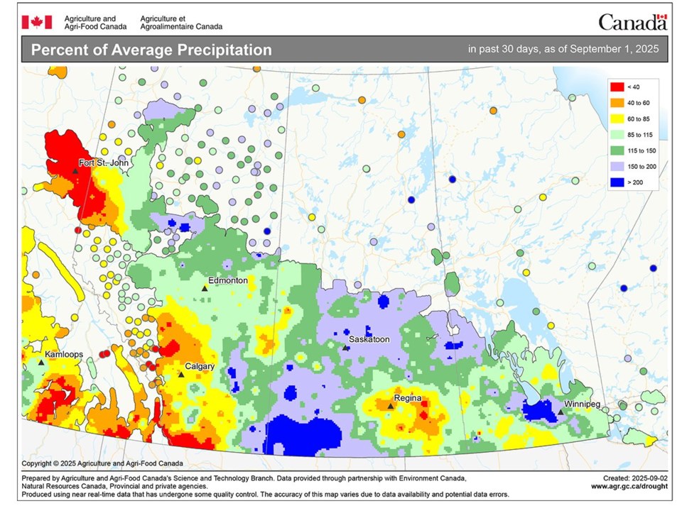
This map shows the total amount of precipitation that fell in August as a percentage of average. Western Alberta and east-central Saskatchewan saw below average amounts, while parts of Manitoba, north-central and south-western Saskatchewan saw above average amounts. | Source: Environment Canada, Agriculture Canada
Now on to our look at the latest fall forecasts. The Old Farmer’s Almanac is calling for near to slightly above average temperatures from September to November, along with near average amounts of precipitation. The Canadian Farmers Almanac appears to be calling for the September to November period to be cooler and wetter than average.
Moving on the different weather models. NOAA’s forecast looks to be calling for near-average temperatures and precipitation right across the prairies from September right through to November. The CFS is currently calling for well above average temperatures in September, transitioning to slightly above average in October and near average in November. Their precipitation forecast is calling for below-average amounts in September, with October and November coming in near to slightly above average, with southern Manitoba and western Alberta seeing the wettest conditions.
The Canadian CanSIPS model is calling for near to above average temperatures in September and October, cooling to near average temperatures in November. Their precipitation forecast is calling for near-average amounts across all three months. The ECMWF model is calling for warmer-than-average temperatures in September and October, with November coming in near average. Their precipitation forecast is calling for near-average amounts for all three months, with parts of southern and western Alberta seeing slightly above average values.
Personally, I am leaning towards a warmer-than-average start to fall, with temperatures transitioning to near average by November. Precipitation will be near average in September, with October and November coming in near to slightly above average. In our next issue, we will continue our look at extreme rainfall.
About the author
Related Coverage
Factors that can cause heavy rainfall
Relative humidity linked to dew point
Soybeans, peas flag under drought conditions
Heat waves combine sunshine and sinking air
Above average temperatures expected
Blocking patterns lead to heat waves


